"Twenty years from now you will be more disappointed by the things you didn't do than by the ones you did do. So throw off the bowlines. Sail away from the safe harbour. Catch the trade winds in your sails. Explore. Dream. Discover".
Good old Mark Twain
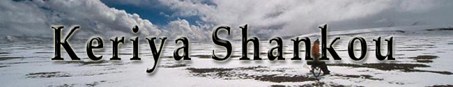
Mt. Mustagh Ata and Keriya Shankou
The Guinness record attempt
 In
winter 2001, I came up with an idea to attempt to set a new Guinness record
in altitude cycling on Mt. Mustagh Ata - two years after last record. Motivation
came from a story about a Polish guy who had climbed even higher with his bike
and a website where a Hungarian team announced they would try to beat our Guinness
record (however, the Polish biker never applied Guinness for
recognition of his record, while the Hungarian attempt never took place). I
joined forces with a hard-core Swedish biker, Janne Corax, who took care of
sponsors and participant matters, while I arranged climbing permit, dinner tent
and transportation through the China Xinjiang Mountaineering Association. Janne
managed to talk the biggest outdoor website in Sweden into making an add for
the expedition and some overwhelming 60 persons wanted to participate. After
a long and complicated selection process, the team ended up included eight climbers
and four bikers. After a weekend team meeting in Sweden where most tasks and
logistics became sorted out, the team assembled in Kashgar in Westchina in July
and went up to Mustagh Ata base camp in bus and by bike.
In
winter 2001, I came up with an idea to attempt to set a new Guinness record
in altitude cycling on Mt. Mustagh Ata - two years after last record. Motivation
came from a story about a Polish guy who had climbed even higher with his bike
and a website where a Hungarian team announced they would try to beat our Guinness
record (however, the Polish biker never applied Guinness for
recognition of his record, while the Hungarian attempt never took place). I
joined forces with a hard-core Swedish biker, Janne Corax, who took care of
sponsors and participant matters, while I arranged climbing permit, dinner tent
and transportation through the China Xinjiang Mountaineering Association. Janne
managed to talk the biggest outdoor website in Sweden into making an add for
the expedition and some overwhelming 60 persons wanted to participate. After
a long and complicated selection process, the team ended up included eight climbers
and four bikers. After a weekend team meeting in Sweden where most tasks and
logistics became sorted out, the team assembled in Kashgar in Westchina in July
and went up to Mustagh Ata base camp in bus and by bike.
 What
happened?
What
happened?
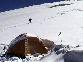
Mt. Mustagh revealed herself from the bad side this year, the icefall now included steep icewalls and black wide crevasses while bad weather was order of the day. French Sebastian reached the summit, Swedish Josephine reached 7500 in bad weather while Swedish Olof reached around 7400 meters, turned back by double vision. What happened to the crazy bikers? We biked some 240 km from Kashgar at 1300 meters up to basecamp at 4430 meters in two teams. Here the actual climbing part started. Honza ran into serious altitude problems and had to stay in base camp - Steffan lost spirit on dragging his bike and left it in base camp for normal mountaineering - Janne was very strong but got sick and had to give up on the record attempt - I dragged my bloody bike up to 6350 meters, just to realise my stove didn't work and had to go down again.
Bottom line: Sieg, Luc and I still hold the Guinness record in altitude cycling together.
Keriya Shankou
 After
this, the plan became killing some time cycling to near the border to India
on military roads and maybe trek to the Karakoram
pass which Sir Younghuspand went
over more than a century ago. Finishing this warm-up trip, the plan was to cycle
over the Keriya Shankou pass on an
old trade path connecting India's Ladakh and former East Turkistan, more specific
from Kasmir's Leh to Yutian on the southern road in the outskirts of the Taklamakan
desert in west China. Finally, the plan was to cross south through north Tibet's
Chang Tang ("northern plain") from Taklamakan's Qiemo to the northern
route in central Tibet - some 1000 km. off-road trip in very harsh climate and
geographic conditions without presence of human beings except for the southernmost
hemisphere of the region.
After
this, the plan became killing some time cycling to near the border to India
on military roads and maybe trek to the Karakoram
pass which Sir Younghuspand went
over more than a century ago. Finishing this warm-up trip, the plan was to cycle
over the Keriya Shankou pass on an
old trade path connecting India's Ladakh and former East Turkistan, more specific
from Kasmir's Leh to Yutian on the southern road in the outskirts of the Taklamakan
desert in west China. Finally, the plan was to cross south through north Tibet's
Chang Tang ("northern plain") from Taklamakan's Qiemo to the northern
route in central Tibet - some 1000 km. off-road trip in very harsh climate and
geographic conditions without presence of human beings except for the southernmost
hemisphere of the region.
What happened?
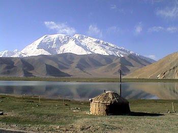
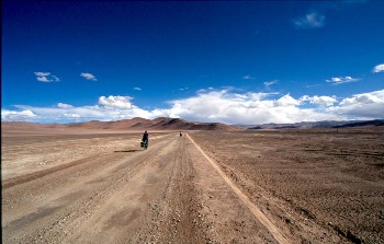
After staying 12 days(!) in the ancient silk road town Kashgar - Janne, his girlfriend Nadine and I cycled some 1000 km mostly on gravel road 219 and hit the official border to Tibet, before turning east. Some 100s km before, after crossing a 5133 meters pass, a Chinese military landcrusier with anything than happy officers stopped us on a military road toward India and escorted us for hours some 20 km back down the pass toward the main road to make sure we didn't continue. Due to the "shot first - ask later" policy near the border and the mood of the army officers we encountered, we decided to give up on the Karakoram pass plan and continued on the main road through Aksai Chin (Chinese Kashmir) toward Tibet.
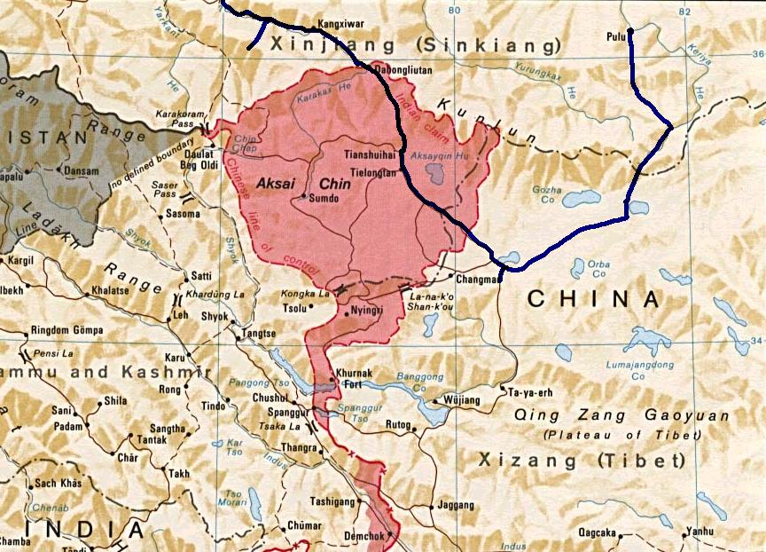 We
entered Tibet and cycled some 150 km east into the wilderness on a vanishing
truck trail in three days and reached the turquoise blue Bangdag lake in a broad
and spectacular valley with the ever-present low clouds in Tibet. This vally
was commonly used when European explorers penetrated Chang Tang one centry ago.
We turned north and crossed a small pass, before turning east, walking 1½
day along the bank of a river leading meltwater down to Gotza lake from a nameless
6360 meters peak. A wide gravel riverbed opened up to the north, but the Keriya
pass was hidden behind a small range of steep hills which revealed a small passage
on our left. We dragged our bikes past the hills and began approaching the Keriya
pass here at the beginning of the southern part of the West Kunlun Shan mountain
range (locals call the Kunlun range: "mountains of blinding darkness").
We
entered Tibet and cycled some 150 km east into the wilderness on a vanishing
truck trail in three days and reached the turquoise blue Bangdag lake in a broad
and spectacular valley with the ever-present low clouds in Tibet. This vally
was commonly used when European explorers penetrated Chang Tang one centry ago.
We turned north and crossed a small pass, before turning east, walking 1½
day along the bank of a river leading meltwater down to Gotza lake from a nameless
6360 meters peak. A wide gravel riverbed opened up to the north, but the Keriya
pass was hidden behind a small range of steep hills which revealed a small passage
on our left. We dragged our bikes past the hills and began approaching the Keriya
pass here at the beginning of the southern part of the West Kunlun Shan mountain
range (locals call the Kunlun range: "mountains of blinding darkness").
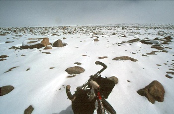
It was a nightmare. We pushed our bikes from morning to evening through the mud laying just above the perma frost layer, through icy riverstreams and around moraine stones of all sizes - and on average only gained 16 km. in days frequently hit by snowstorms (beginning of September). At night-time, I was freezing in my -40 C sleeping bag, partly due to weightloss and moisture. Its amazing how the Tibetan antelopes we saw up here survive these hostile conditions. We struggled hard against soft ground, but Sven Hedin had undertaken much worse conditions elsewhere in Tibet in year 1900:
"Pouring rain, marshy ground, quicksand! Detestable! Again we had to negotiate a muddy range. Two tired camels were being led behind. One of them reached our camp. The other sank so badly into the mud on the top of the pass, that every effort to pull him out failed", (My life as an explorer).
 The
absurd flat pass itself was 5604 meters and in the proximity of the snowline
with a low, but still spectacular mountain range on our left partly enclosed
by a massive ice-cap stretching some 100 km to the west. The 600 meters descend
along the source of upper Keriya river took us to the steep 5513 meter Atotam
pass, the north side descend marking the starting point of a some 70 km muddy
disintegrated gravel road constructed by Kunmindang warprisners in the late
60s during the intense hunt for Uranium in Tibet. Despite all their suffering,
its highly doubtful any vehicle ever has used it. Marching over the 5022 meters
Topolato pass opened up a 50 km long and 20 km wide desert steppe plateau in
the middle of the Kunlun range called Achik Kul basin marked with two salt lakes
in the centre at 4520 meters. Only life seen here was a solitary wild yak. By
now - we were all exhausted and agreed to cancel the big Chang Tang trip. And
all this was only before beginning of hell!
The
absurd flat pass itself was 5604 meters and in the proximity of the snowline
with a low, but still spectacular mountain range on our left partly enclosed
by a massive ice-cap stretching some 100 km to the west. The 600 meters descend
along the source of upper Keriya river took us to the steep 5513 meter Atotam
pass, the north side descend marking the starting point of a some 70 km muddy
disintegrated gravel road constructed by Kunmindang warprisners in the late
60s during the intense hunt for Uranium in Tibet. Despite all their suffering,
its highly doubtful any vehicle ever has used it. Marching over the 5022 meters
Topolato pass opened up a 50 km long and 20 km wide desert steppe plateau in
the middle of the Kunlun range called Achik Kul basin marked with two salt lakes
in the centre at 4520 meters. Only life seen here was a solitary wild yak. By
now - we were all exhausted and agreed to cancel the big Chang Tang trip. And
all this was only before beginning of hell!
 We
went across the infertile and dry plateau in 1½ days and after walking
over the 5138 meters Atoto pass dotted with donkey skeletons all over, the steep
descend down to a Taklamakan desert village called Pulu at 2550 meters altitude
some 25 km away began. I hoped the road sections continued, but there were nothing
but a long frightening narrow river gorge squeezed by very steep mountain walls,
the bottom full of boulders, just as Janne had predicted. By then, food was
very low because we prior to leaving road 219 completely misjudged the possible
duration of this trade path quest. I had been eating only two (one day, three)
small bags of 75 gram instant noodles a day for some days and constantly hallucinated
about food as my stomach came to a complete standstill. The daily fight against
the malfunctioning stove had somehow become a secondary problem. As we descended,
mood was below zero and Janne and I got really mad at each other and I ended
up going solo down through the Aksu river gorge, crossing the ever increasing
riverstream countless times, cutting my feet repeatedly which made walking painful
and difficult. I was mentally and physically utterly exhausted and at one stage
while desperately trying to find a feasible passage around a 100 meters waterfall,
I seriously considered leaving bike and gear behind. Still, nature was mercy
in its own way - heavy rain during the descend would have turned the situation
from bad into directly life threatening.
We
went across the infertile and dry plateau in 1½ days and after walking
over the 5138 meters Atoto pass dotted with donkey skeletons all over, the steep
descend down to a Taklamakan desert village called Pulu at 2550 meters altitude
some 25 km away began. I hoped the road sections continued, but there were nothing
but a long frightening narrow river gorge squeezed by very steep mountain walls,
the bottom full of boulders, just as Janne had predicted. By then, food was
very low because we prior to leaving road 219 completely misjudged the possible
duration of this trade path quest. I had been eating only two (one day, three)
small bags of 75 gram instant noodles a day for some days and constantly hallucinated
about food as my stomach came to a complete standstill. The daily fight against
the malfunctioning stove had somehow become a secondary problem. As we descended,
mood was below zero and Janne and I got really mad at each other and I ended
up going solo down through the Aksu river gorge, crossing the ever increasing
riverstream countless times, cutting my feet repeatedly which made walking painful
and difficult. I was mentally and physically utterly exhausted and at one stage
while desperately trying to find a feasible passage around a 100 meters waterfall,
I seriously considered leaving bike and gear behind. Still, nature was mercy
in its own way - heavy rain during the descend would have turned the situation
from bad into directly life threatening.
Eventually, after only reaching 7,5 km further during a grueling long day of hardship and frustrations with only one package of noodles left, I met 12 astound shepherds. The next day, while the sharp Kunlun mountains abruptly undertook transformation into big browngreen rolling hills, I followed nine of them and their sheep for one day down to Pulu where the local Uyghurs didn't believe the "crossing Keriya" story and some looked upon me as a marching daemon from the high emptiness in the south. Guess I looked like that. Here my hair felt off in tufts and here I had my first toilet visit in three full days as well. The next morning, I got a ride for free with three local-government officials on an one-day inspection visit and reached Yutian after driving along a truck trail crossing through soft sand dunes marking the onset of the Taklamakan desert. After staying a few hours in Yutian, I took a bus across the Taklamakan desert to Urumqi and flew to Beijing the next morning. A few days later, after fighting a food poisoning gotting while my uncontrollable hunger still ignored my constant overfilled stomach, I flew home to Denmark.
In all, we cycled 14 continuous days around or above 5000 meters while cycling across Aksai Chin and on the old trade path - we didn't see human beings for 12 continuous days - I lost 13 kg in all - 3½ kg. on Mustagh Ata, gained some while staying the 12 days in Kashgar, but lost this and 9½ kg. more during the Keriya pass trip.
What did the Keriya trip teach me?
1) I discovered new sides of myself which I didn't realise I had - some have to be corrected e.g. - I'm conflict shy which means small matters accumulate and in the end I become really mad at people. Ultimately it ends up in leaving people. That's no good - especially not in a rough place.
2) Amazingly, somehow I miss the physical hardship from the Keriya trip - difficult to explain why - I guess it got something to do with feeling alive in the moment - being on the edge in a place where planing and endurance are crucial - being in a place where every single day is printed into mind forever.
3) I have to go back to Tibet again for Chang Tang.
4) Never ever underestimate Tibet's Chang Tang.
/Martin
Here a timetable + a partly done photopage from the trip.