The search
for the highest road on earth
"Near the Ship-la we crossed
the border line of Tibet and India. Here, for the last time, we were at an altitude
of 16,300 feet. I remained long, gazing toward Tibet, the land of my victories
and my sorrows, the inhospitable land where both man and Nature create obstacles
for the traveller, and from whose dizzying heights the traveller returns with
a whole world of unforgettable, precious memories, in spite of the difficulties."
(Sven Hedin, when leaving Tibet for
the last time in 1908)
Photos from the trip - not
really ready yet...
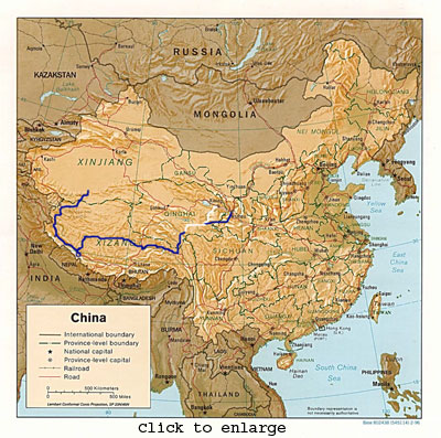
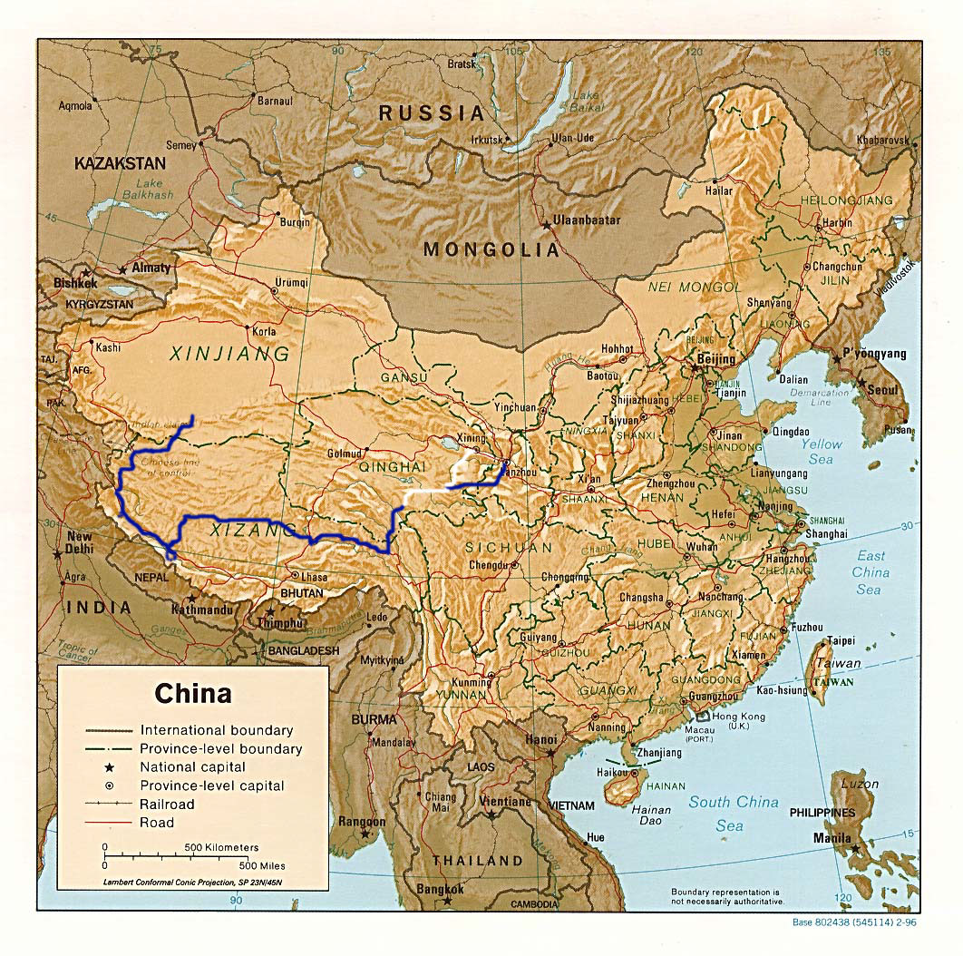
I did two trip in Tibet in 2004. This, the second trip - august
to november - was a 4604 km adventurous bicycle odyssey with American Jeff Garnand
on roads through northeast and west-Tibet which included climbing a 6189 meters
mountain before going off-road 470 km into Tibet's uninhabited Chang Tang without
seeing people for 14 days. No doubt my best Tibet trip.
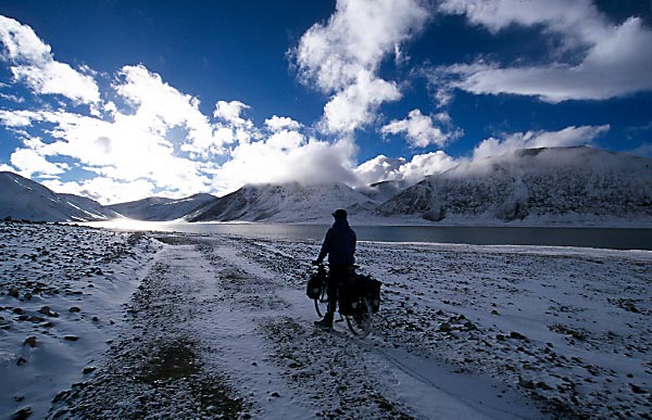
 Interconnected
shallow lakes turn up on our right hand while we cycle gasping into the cold
mountain mist. We don't understand it, Djuma La, as the Tibetan nomads we camped
beside yesterday labelled the forthcoming pass, must be visible soon, but we
see nothing. We are cycling at 5300 meters altitude and the previous two days
climbed a 6189 meters (unclimbed?) peak in the Gandise range and cycled over
a well-maintained 5535 meters road pass we had never heard about before,one
of the highest road passes on earth. What is going on?
Interconnected
shallow lakes turn up on our right hand while we cycle gasping into the cold
mountain mist. We don't understand it, Djuma La, as the Tibetan nomads we camped
beside yesterday labelled the forthcoming pass, must be visible soon, but we
see nothing. We are cycling at 5300 meters altitude and the previous two days
climbed a 6189 meters (unclimbed?) peak in the Gandise range and cycled over
a well-maintained 5535 meters road pass we had never heard about before,one
of the highest road passes on earth. What is going on?
After last winter’s 3047km solo bike trip through Tibet, I somehow felt eager
to come back to Tibet soon again. I got in contact with American Jeff Garnard
whom I met cycling in Pakistani Kashmir in ‘99 when India and Pakistan were
on the verge of war. Jeff is an adventurer by heart and quit his extremely well-paid
job in IT and left his girlfriend behind to make probably the longest ever Tibet
trip by bike: a figure of eight route across the whole Tibetan plateau. Jeff's
plan is not just hot air - in ‘99 he cycled across the whole of Tibet in just
2 ½ months. I'm not that ambitious and before departure our joint cycling
plan became starting out from Lanzhou in the Chinese province of Gansu in order
to cycle across the Tibetan plateau together. Jeff arrived in Lanzhou by train
from Beijing while I flew in from Beijing on the 7th August, arriving in China
a few days after Jeff.
We only enjoyed a day in this key point on the old Silk Road before starting
cycling southeast with the idea of crossing into Qinghai province. The surrounding
hills outside Lanzhou were a dry barren sandy experience while the temperature
midday reached well over 30 degrees, certainly not my favourite environment
for cycling. Worst of all, though, were the trucks transporting bees for pollinating
crops in the surrounding fields. For some reason they couldn’t stay away from
me. On one occasion while about thirty bees were around me, one bee stung me
next to my eye, causing the rest of the devils to try to follow his example.
Here I learned that I run faster than I cycle. Those days with the bees were
really a torment! The landscape slowly changed character into wide-open green
lush valleys where nomads on motorbikes were herding their sheep and yaks. We
began cycling on the smallest roads we could find on my Chinese maps, roads
which became extremely muddy and unpaved before crossing into Qinghai province.
Later we reached the Yellow river gorge and climbed a steep 4000m pass after
crossing the river and felt satisfied with our progress till then. As we were
about to start out the next day, I discovered a huge crack in my rear rim. It
was like being hit by a hammer, but somehow I felt very lucky - had the rim
failed while cycling down a deep gorge the day before toward the yellow river
at 50+ km/h it could have been end of my Tibet trips. It turned out the crack
came from my last winter tour, the whole inner double wall was cracked nearly
all the way around. I have never heard of such damage before. I took a chance
and cycled 56km with Jeff to a county capital where I grabbed a bus the next
morning to Xining, capital of the Qinghai province. The 500+ km trip took more
than 12 hours before I found a hotel in the evening. Before leaving Jeff, we
agreed to meet some 600 km later on our planned route in a town called Yushu.
Finding quality spare parts for a bike can be quite a problem in China. Luckily,
I have a really good friend in Siegfried Verheijke, Belgium Trade Commissioner
in Beijing (we set a Guinness record for altitude cycling together). When emailing
him, he instantly set heaven and earth on fire to make sure a wheel set was
sent express from Beijing to Xining. I received the wheel set and was as wild
as a lion in a cage to get back on the road again after being among backpackers
for three days. I simply don't share their concept of travelling. My destination
is the road between their highlights - my destination is the raw, long exhausting
hauls on dirt roads which drain all mental and physical strength. I somehow
belong to the mountains, the vast open plains at high altitude which to me represent
the ultimate freedom; no obligations, no limits, only pure freedom.
 The 1200km detour was crowned with a 400km nightmare minivan trip before reaching
Yushu. The minivan of course got a puncture on the back left tyre and the spare
tyre fared no better. We were supposed to get assistance from Yushu but nothing
happened, so the driver tried to drive with a flat tyre. The car coming with
a spare tyre expected to see a stopped minivan and drove past us, to our driver's
extreme frustration, but finally came back and found us. Then 160 km of road
construction before we reached Yushu. It was 3am by the time, completely wasted,
I got into a truck guesthouse room in Yushu. I met Jeff the next day and spend
most of the day shopping and emailing in an internet café where a middle-aged
monk was playing CounterStrike – a shot-them-up-game. The next day we resumed
our bike trip out of Yushu together. Here, another tremendous shock hit. We
were cycling side by side just outside town when a blue Dong Feng truck overtook
us at slow speed. A yak-ox suddenly jumped out in front of the truck from the
left side of the road. The truck could not avoid the yak and hit it front on,
throwing the animal several metres through the air. Then the truck swayed to
the left at slow speed, broke through a barrier and fell three vertical meters
into a riverbed and landed on its side. Jeff and I threw our bikes down by the
road and ran over. A girl was already out of the truck when we got there, washing
her bloody face in the river. Two men also came out of the truck, looking little
better. A crowd quickly assembled around the place, but no one tried to help
in any way. Jeff and I were shocked again when no one even offered to drive
the wounded back to town and they had to walk back. One of the downsides of
China: few people will help others in emergencies. A few days later, we camped
next to a Chorchen – a religious tower - high up a hill. In the evening an immense
thunder system moved in and lightning hit frightening near us while our tents
were fluttering in the strong wind. No doubt, we were both very scared, but
the thunder calmed down, as we were about to leave our tents for lower grounds.
In this area we began entering a really mountainous area and plunged into official
Tibet after crossing an easy pass. Here we nervously approached a white checkpoint
building with a reddish Chinese flag flapping above. Luckily, the guards just
smiled and waved to us from the building - we were now in Tibet without problems.
The 1200km detour was crowned with a 400km nightmare minivan trip before reaching
Yushu. The minivan of course got a puncture on the back left tyre and the spare
tyre fared no better. We were supposed to get assistance from Yushu but nothing
happened, so the driver tried to drive with a flat tyre. The car coming with
a spare tyre expected to see a stopped minivan and drove past us, to our driver's
extreme frustration, but finally came back and found us. Then 160 km of road
construction before we reached Yushu. It was 3am by the time, completely wasted,
I got into a truck guesthouse room in Yushu. I met Jeff the next day and spend
most of the day shopping and emailing in an internet café where a middle-aged
monk was playing CounterStrike – a shot-them-up-game. The next day we resumed
our bike trip out of Yushu together. Here, another tremendous shock hit. We
were cycling side by side just outside town when a blue Dong Feng truck overtook
us at slow speed. A yak-ox suddenly jumped out in front of the truck from the
left side of the road. The truck could not avoid the yak and hit it front on,
throwing the animal several metres through the air. Then the truck swayed to
the left at slow speed, broke through a barrier and fell three vertical meters
into a riverbed and landed on its side. Jeff and I threw our bikes down by the
road and ran over. A girl was already out of the truck when we got there, washing
her bloody face in the river. Two men also came out of the truck, looking little
better. A crowd quickly assembled around the place, but no one tried to help
in any way. Jeff and I were shocked again when no one even offered to drive
the wounded back to town and they had to walk back. One of the downsides of
China: few people will help others in emergencies. A few days later, we camped
next to a Chorchen – a religious tower - high up a hill. In the evening an immense
thunder system moved in and lightning hit frightening near us while our tents
were fluttering in the strong wind. No doubt, we were both very scared, but
the thunder calmed down, as we were about to leave our tents for lower grounds.
In this area we began entering a really mountainous area and plunged into official
Tibet after crossing an easy pass. Here we nervously approached a white checkpoint
building with a reddish Chinese flag flapping above. Luckily, the guards just
smiled and waved to us from the building - we were now in Tibet without problems.
The next days were spent climbing up and down in the hilly terrain with rain
most nights. Climbing passes became daily events. We both managed to get food
poisoning on different occasions in this area, throwing up half the night and
struggling through the next day of cycling. After 1800 km of cycling (2400 km
for Jeff) we finally reached Nagqu, a major town with approximately 100,000
inhabitants. We had been talking about this place as a midway goal, joking that
the streets would be paved with gold there (we hoped at least the food would
be better). Completely worn down, I took a three-day rest here last winter after
extreme headwinds during the day and temperatures down to around -35°C at
night. Our stay here at 4200 meters lasted only one day and included our first
bath since Yushu more than 14 days before. We left Nagqu and cycled 40 km north
on the paved Golmud highway along the railroad under construction to Lhasa and
then turned off a shortcut to the northern route leading to western Tibet. This
was the beginning of a non-existent road, trucks having formed their own tracks
through the wide sandy valleys. Sometimes the main track divided into 15 smaller
tracks. Here we began seeing wildlife on a large scale: Chirus (Tibetan antelopes)
fleeing upon seeing us while Kiangs (Tibetan asses) curiously observed us riding
by. Cycling around the enormous salt lakes - one more than 100km long - was
a mental blessing and we camped next to the shores whenever we could. Strangely,
we never discovered at what point we actually reached the northern route from
the shortcut due to the track confusion, but it happened after about 260 km.
Here we tried to adjust our cycling after the location of the Hui (Muslim Han-Chinese)
restaurants around 80 km from each other, which were often just a tent. That
food was a blessing - homemade noodle soup with vegetables and bread. The Tibetan
teahouses offer at best just instant noodle soup or Tsampa, barley flour added
with butter tea. After 9 days of cycling from Nagqu, we reached a small town
called Nima, at 4400 meters altitude and about 550 km from Nagqu. This town
of around 5000 people serves as county capital for an area lager than 150,000
km² - more than three times the size of Denmark. A 27 year-old Chinese
construction engineer we met here was extremely helpful, lending us his laptop
for emailing since there were no internet cafés in town. He had stayed
here for three years co-leading a $10 million town centre construction programme.
But most interesting was the fact that he had a wolf cub as a pet, which he
found in the Chang Tang nature preserve to the north of town. It was locked
up in the courtyard of the town’s army weapons depot to protect it from the
Tibetans in town, who had attacked it once and wounded its hind leg. Tibetan
nomads hate wolves because they attack livestock. It was quite cute and I ended
up playing with this bundle of fur for half an hour. Wind harassed us as we
continued the 350 km toward Gerze on the northern route. Our average speed fell
to 6-8 km per hour when the headwind intensified to near storm force, draining
all physical and mental energy. Searching for a place to eat we ran into an
open goldmine run by the Tibetan local government. Some of the gold diggers
invited us into their camp and insisted we should eat there. They told us that
the annual production of gold was between 600 and 700kg at this site. I am quite
interested in the past exploration of western Tibet and their information that
it was an Englishman who discovered the place 100 years ago was extremely interesting
to me. On our departure they stocked us up with Chinese bread called manto and
wished us good luck. Gerze town was much bigger than Nima, not exactly corresponding
with what the construction engineer had told us. If things go as I hope, I shall
go to this town next summer to make a solo crossing of northern Tibet's Chang
Tang nature preserve, a 1000 km bike trip in uninhabited surroundings, a trip
which will take at least 45 days; more than one month in absolute solitude.
This represents the ultimate Tibet bike trip to me.
We found a bad $8 per person room and hung around town for one day before continuing.
We would like to have rested longer but our visa situation began to worry us.
We both had three-month Chinese visas and we were both 1 ½ months into
our trip. The question was; would it be possible to extend them in the prefecture
capital in western Tibet, Ali? If not, it meant we would have to shorten the
trip. We cycled on and reached Yanhu, a small busy town full of small shops
and restaurants situated just next to a large salt lake (yanhu means salt lake).
Outside town to the west was a small compact campsite crowded with Tibetan pilgrims
and old blue Dong Feng trucks parked nearby. Undoubtedly their destination was
Mt Kailash, south of the Gangdise/Transhimalaya mountain range we were now in
front of. Mt Kailash is the centre of the universe in Tibetan Buddhism and thousands
of pilgrims go there every year. We continued south the next day into the Transhimalaya
mountain range in order to reach a small settlement called Yagra. To our surprise
the road, which according to all our maps should follow a river valley up to
a lake next to the settlement, instead led over a 5290m pass, our highest point
until now. We descended down to Yagra the next day and discovered a much bigger
settlement than expected with shopping tents in lines at the north end of the
place. I cursed myself for buying supplies in Gerze for a 12 days off-road crossing
of Transhimalaya - everything we needed was here. A Tibetan in town gave us
some precise road information and we started out the next day to find a way
over the Transhimalaya to the Yalung valley on the south side. To our astonishment
the road led us into a side valley. Looking at my 1:500,000 Tactical Pilot Charts,
we realized a major road pass must be in front - surely higher than 5400m -
among the highest on earth. The official highest road pass is in India and the
altitude is claimed to be above 5600 meters, but cyclists riding there with
GPS have found it to be only around 5450 meters. The excitement gets a grip
on us - what is awaiting us? We cycle up a well kept road beside a small stream
and in the evening come to a point where we suddenly see a towering peak in
front of us, according to our maps 6180m high. We are completely flabbergasted
and agree to attempt to climb it the next day. While riding higher up the road
to make a base camp for the climb we suddenly see the wall on our left leading
up to the road pass as well, with switchback bends all the way to the top. Jeff
is in a state of ecstasy - he loves passes and he now sees what may be the highest
road pass on earth - it must be higher than 5500 meters high!
The next day we leave base camp early and after traversing 8-10 km over a small
hill, we take a rest on a pass saddle before we begin the actual climb. We ascend
quite fast, more than 300 meters/hour and in just three hours from the base
camp at 5300 meters we find ourselves on the top of the peak at 6189 meters
altitude. The wind from the south is intense and we seek shelter on the north
side while admiring the Transhimalayan peaks around us in the nearly cloud-free
sky. We don't find any sign of people having been up here before and build a
small chorchen of stones and walk down again, exhausted. The next day, we ascend
the 5535 meters road pass and I cannot help trying to lift my bike over my head
while Jeff films the event with my video camera, but it is too heavy. We are
both certain that we are the first to cycle this pass. We cycle down from the
pass next to a river and end up camping by a nomad tent in an open windy valley.
In the evening they treat us to butter tea and tsampa and tell us about their
families and the area. They also try to tell us about the pass ahead in a manner,
which makes us worry a bit. Next morning they give us enough tsampa and rice
for several days. Had we known what was waiting, we might have hesitated a bit.
We ended up cycling more than 35 km above 5300 meters altitude, peaking at a
5428 meters pass at the end of a 15 km long lake where we camped before riding
over the pass the following morning. Riding along the lake, we cycled through
a small snowstorm and could easily have gotten into serious problems had it
not stopped snowing.
After descending the Transhimalaya, we cycled around Turkish-blue Lake Manasarovar,
a roundtrip of 100km, a two-day trip where we stayed overnight for free at a
monastery complex after three monks had grabbed our bikes and cycled around
on them for an hour. Then came the trip to Mt Kailash. We cycled to Darchen,
the town lying at the foot of the mountain, paid $50 each for a permit and a
fine for being in the area, stored our bikes in the home of a friendly bank
employee we met in town and began the trek. We had really bad backpacks, Jeff
was worst off with a bag with really thin straps. Surely we would end up with
shoulder pains! We managed to walk some 15 km of the total 53 km during the
rest of the day on the west side of Mt Kailash during our clockwise kora around
the mountain. We spent the night in Jeff's tent and watched devoted pilgrims
passing us in the morning light while packing. We came across a group of young
pilgrims on a one-day kora while ascending toward the Dromo La pass on the north
side of Kailash. We followed them for some time and while filming them, they
urged me to follow them through a small tunnel system among some rocks. I got
part of the way but they soon realised that my 185cm height would not be able
to make the whole way through. Up on top of the pass at 5600 meters altitude
were the traditional prayer flags fluttering loudly in the wind and Tibetans
celebrating the ascent by throwing dry Tsampa into the air as a religious offering.
We began the descent; a long haul to Darchen waited. My feet were pretty swollen,
the shoulder now hurt a lot, forcing me to bend forward while walking - the
fun was gone. Jeff was in front as usual, just as when cycling, daylight vanished
slowly and it became cold. Not until darkness approached did I arrive back in
town, completely beaten up like last time (I first did this kora three years
ago during a bike trip across west Tibet). I met Jeff again in the banker’s
house where the banker’s grandparents were singing religious songs while he
was out having a drink in town. Jeff sat staring apathetically into the air
when I arrived. Next day, we met an Indian guy who had walked around Kailash
155 times - more than 8000km! 117 times should be enough to achieve nirvana,
but nothing happened to him after the 117th trip; instead he got a vision to
continue his koras around Kailash. I guess he must have gotten a bit disappointed.
We had a long talk with him and he showed us a small booklet presenting a plan
for 100,000 Indian pilgrims coming to Kailash every year. Some of it sounded
quite appealing, other parts were quite far from reality – e.g. helicopter service
at 4600 meters altitude…
We jumped on our bikes and cycled west through the wide Gar river valley, with
7727 meters high Mt Gula Mandatta marking the Himalaya range to the south, next
to West Nepal. Later while cycling in the valley, we had to cycle in a small
blizzard making cycling less fun as temperatures plunged below -2°C at night.
After a couple of days of cycling, we ate at a Chinese restaurant next to an
army base. Unfortunately, this led to food poisoning again and I had to spend
half the night waiting for the inevitable throwing-up session. This was a great
setback for our plans to try to get over what should be the highest road pass
on earth at 5900 meters, the road not having been in use for a long period.
It had to be attempted, so after half a rest day we went into a narrow valley
south of the road, throwing our faith into a map from a guidebook on Tibet from
1994 where the pass is shown precisely. After 10 km of cycling on a really good
road, we ran into a nomad who said there was no road over the Bogo La pass,
that we would have to walk - and most frighteningly he pointed at a vertical
wall to illustrate the difficulties. Here our hopes fainted, but even though
I was not feeling good, we agreed we had to go further on the good road to see
with our own eyes what was actually up there. The ride further up through the
narrowing valley becoming a gorge was a cobweb of small river crossings, dark
cloud formations moving fast above our heads, giving no indication of whether
bad weather was coming in for real or not. Finally we reached an open valley
at 5100 meters altitude; evidently the nomads had moved down through the gorge
to avoid the cold winter here. To our disappointment, the road disappeared into
nothing at 5200 meters - the Bogo La road pass is a ghost - but obviously this
valley has served as a pilgrim route over Bogo La as big piles of mani stones
laying along a no-longer existent trail going up the pass. We looked carefully
at my TPC map and the 7 contour lines marking 500 feet intervals within 5km
convinced us that it would be hazardous to go over the snowy pass if there was
not some kind of road on the other side. After a -22° C camp here, we descended
to the main road again the next day. Our goal was now Ali, the biggest town
in western Tibet. We have not had much rest during the last two months of cycling
and our minds now focused totally on this "paradise". We cycled right
into the Chinese attempt to let far western China take part in the country’s
massive annual growth, which is currently restricted mainly to the coastal regions
in China: we found an 85km asphalt road leading directly to Ali. Such a difference,
all the stony, sandy washboard we have suffered is replaced here with a superb
paved road. We were ecstatic - normally we prefer gravel roads, but the trip
has taken its toll on us - I have lost more than 10kg and Jeff over 5 kg - we
need rest! We cycled all the way to Ali the same day and have now been staying
here for three days enjoying food and showers like never before. We needed that
after 3642km of cycling (4200 km for Jeff) and climbing more than 33 vertical
kilometres by bike. Fortunately, the police in Ali turned out to be more cooperative
than we had been told and we got a one-month extension of our existing visas,
enough to get us to the Muslim Xinjing province north of the Tibetan plateau.
The trip together is far from finished - on the contrary! It's now that the
serious part begins! We will head up to northwest Tibet, stocked up with more
than three weeks’ food supplies, take a deep breath and then head east into
the western part of the uninhabited Chang Tang nature preserve, second largest
on earth after ice-capped northeast Greenland. Cycling here is mostly impossible
due to soft terrain above the permafrost layer. We'll have to push the bikes
all day and only travel 25km at best in this high-altitude environment mainly
above 5000 meters. Deep into Chang Tang we turn north in order to cross a fault
formation in the Kunlun mountain range leading down to the Taklamakan desert.
We will unfortunately be in Chang Tang in November when wind and temperature
conditions worsen dramatically - frequent strong storms will occur and the temperature
will plunge far below -30° C at night. There is no one to help us out if
something goes wrong in this place, which field biologist Dr. George Schaller
has described as being among the most inaccessible places on earth. This is
the way we want to do it - complete an expedition into Chang Tang on the same
terms as the early Tibet explorers. Coming down from the plateau again after
crossing 500km through Chang Tang and cycling 4000km on the plateau, Jeff will
cycle east to finish his figure of eight trip through southeast Tibet, while
I consider crossing the Taklamakan desert on a 600km oil highway. However, we
will both have to get visa extensions from the local police in a Taklamakan
oasis town called Hotan, but according to our information this should be easier
than in Ali. Sorry, this mail became a bit long, but I got caught up in it…
___________________________
deep into uninhabited Chang Tang , following
a migration route for Tibetan antelopes
ascended over an easy 5141 meters pass and
entered the fault formation separating the West and East Kunlun range, also
birthground to Selektuz river. Then descended down this nearly 100 km. long
and sometimes narrow gorge until reaching Karasai village at 2960 meters at
the edge of Taklamakan desert.
 Interconnected
shallow lakes turn up on our right hand while we cycle gasping into the cold
mountain mist. We don't understand it, Djuma La, as the Tibetan nomads we camped
beside yesterday labelled the forthcoming pass, must be visible soon, but we
see nothing. We are cycling at 5300 meters altitude and the previous two days
climbed a 6189 meters (unclimbed?) peak in the Gandise range and cycled over
a well-maintained 5535 meters road pass we had never heard about before,one
of the highest road passes on earth. What is going on?
Interconnected
shallow lakes turn up on our right hand while we cycle gasping into the cold
mountain mist. We don't understand it, Djuma La, as the Tibetan nomads we camped
beside yesterday labelled the forthcoming pass, must be visible soon, but we
see nothing. We are cycling at 5300 meters altitude and the previous two days
climbed a 6189 meters (unclimbed?) peak in the Gandise range and cycled over
a well-maintained 5535 meters road pass we had never heard about before,one
of the highest road passes on earth. What is going on?