---Under construction!---
"I can hardly conceive a more dreary country to be alone in than
Northern Tibet. The desert could not be worse. One might get through the
days- but the nights! When the cold freezes you to the marrow, and the dark
mountain ranges shut you in and menace you with all sorts of imaginable
evils! (…) I was surrounded by everything I needed- servants, a bodyguard
of Cossacks, nightwatchmen and watchdogs- and yet, when the snowstorms raged
around my yurt and the wolves howled in the mountains, I often felt a sense
of utter loneliness steal over me."
Sven Hedin ”Central Asia and Tibet”, 1903
----------------------------------------------------------
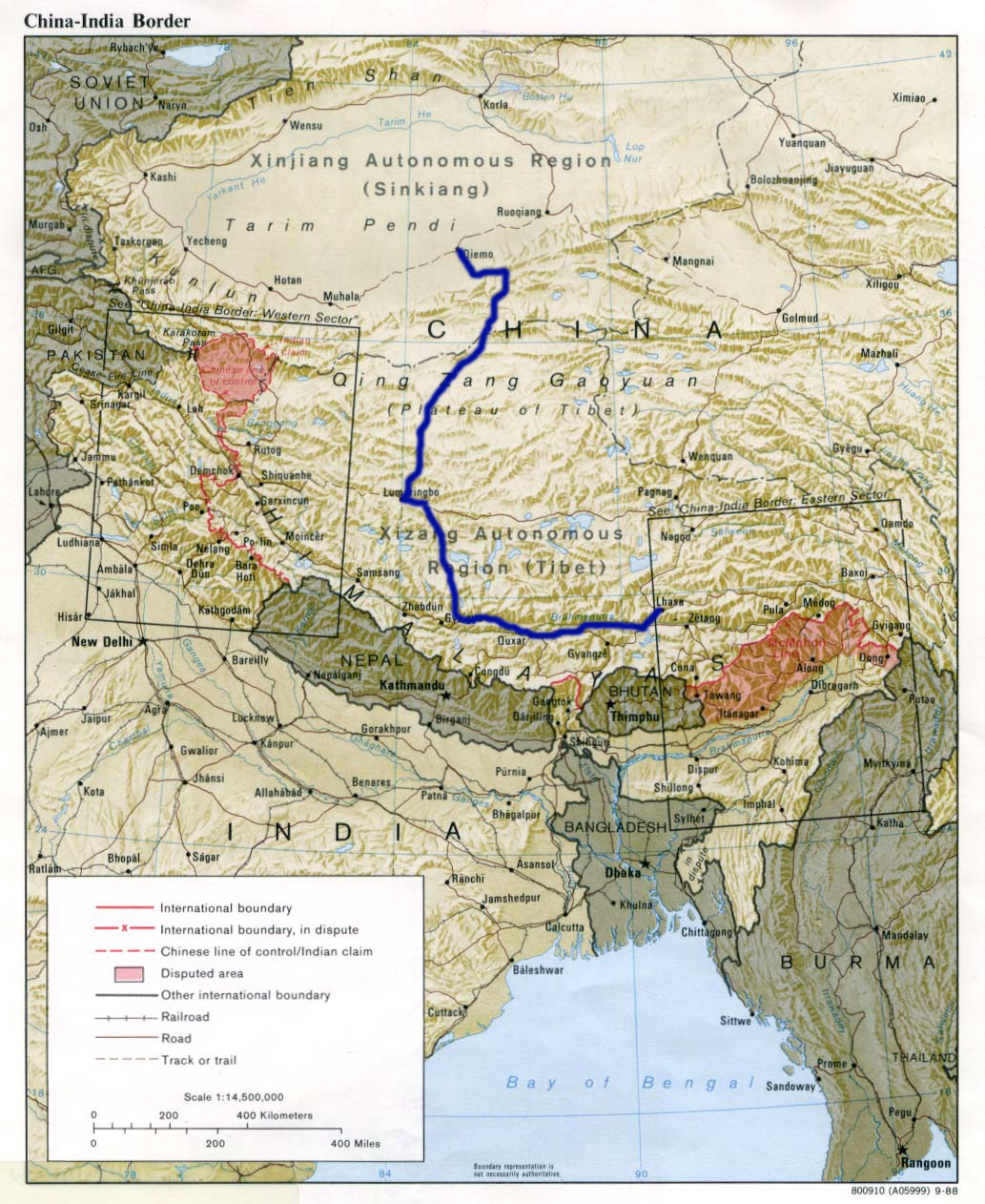
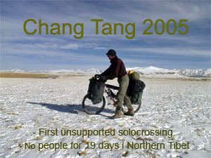
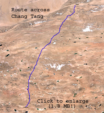
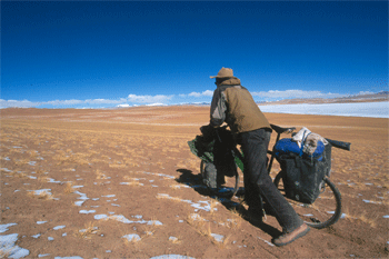
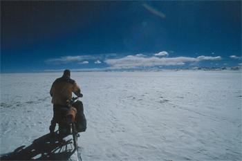
This
autumn I solocrossed Tibets uninhabited Chang Tang. Biked a total of 2400+
kilometers. Had down to -27,3 C at night, roaring wind during daytime, didn't
seen human beings for 19 days, dragged my bike over snowy passes up to over
5500 meters, 35 kg. of food on the bike, wolfs howling in the night nearby
my tent, etc.
Trip report -part one
----- Pictures from
the trip -- Timetable
from the trip (not completed yet)
------------------------------------------------------------------
Introduction prior to trip
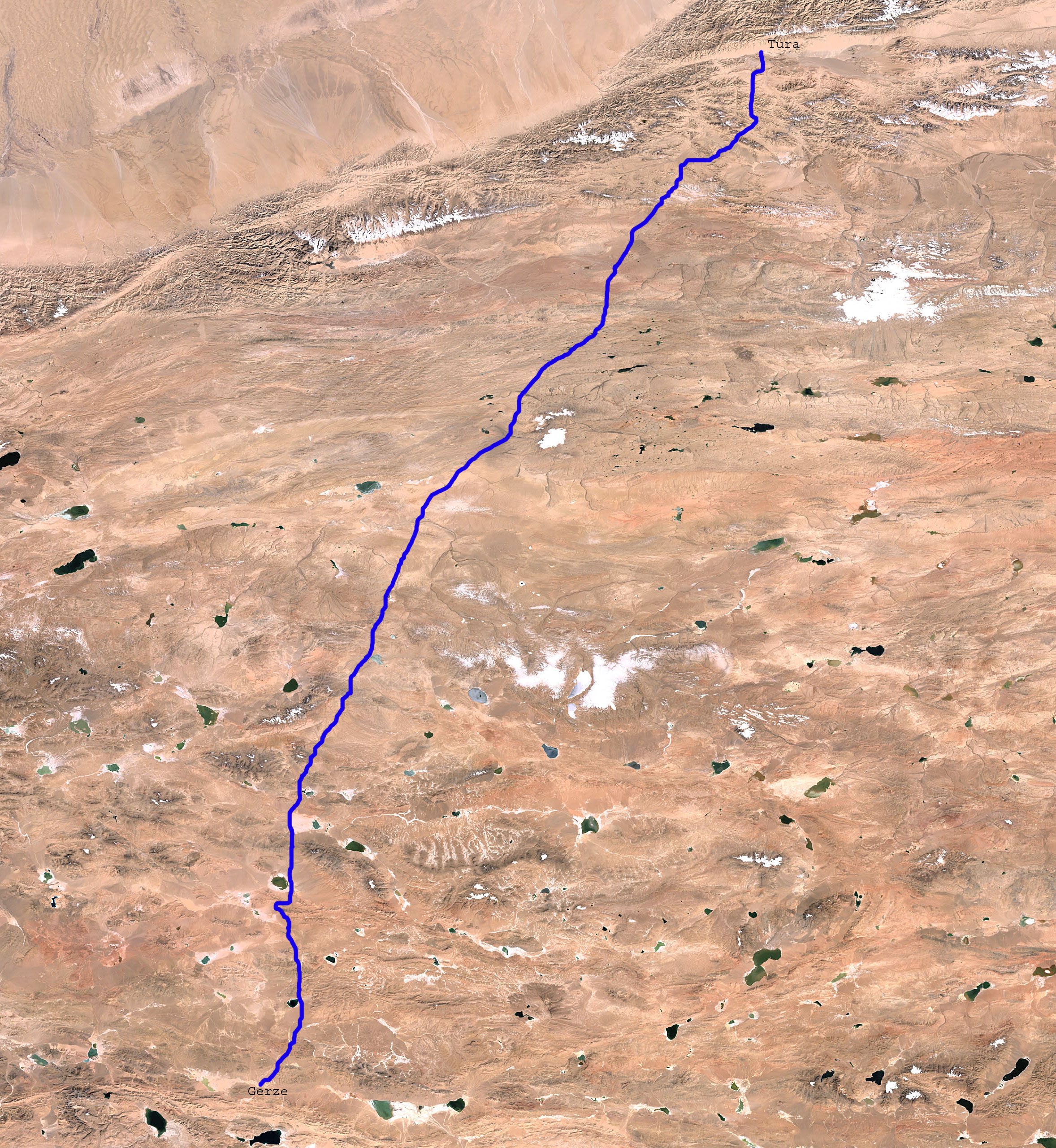
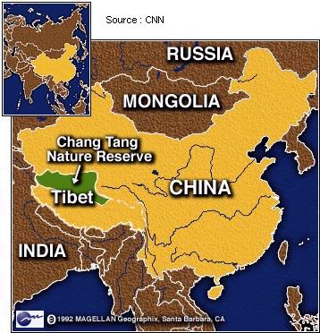
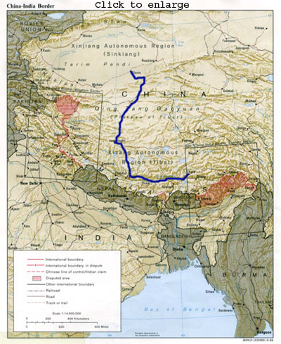 This
autumn is dedicated an attempt to become the first to solocross Tibet's Chang
Tang unsupported through areas never seen by human beings before. The plan is
to bike 1.000 km from Lhasa up to Gerze on the northern route as warming-up
exercise. To the north of Gerze awaits 1.000+ kilometers off-road cycling in
no-mans land at an altitude averaging 5.000 meters where howling wind and nighttemperatures
down to below - 30 C makes polar equipment a must. I have to be self-sufficient
in all terms during the period of 35 - 40 days where it is unlikely to meet
human beings. The whole trip across Chang Tang is estimated to take 45 - 50
days before coming down from the plateau
again to meet civilization in the Taklamakan desert.
This
autumn is dedicated an attempt to become the first to solocross Tibet's Chang
Tang unsupported through areas never seen by human beings before. The plan is
to bike 1.000 km from Lhasa up to Gerze on the northern route as warming-up
exercise. To the north of Gerze awaits 1.000+ kilometers off-road cycling in
no-mans land at an altitude averaging 5.000 meters where howling wind and nighttemperatures
down to below - 30 C makes polar equipment a must. I have to be self-sufficient
in all terms during the period of 35 - 40 days where it is unlikely to meet
human beings. The whole trip across Chang Tang is estimated to take 45 - 50
days before coming down from the plateau
again to meet civilization in the Taklamakan desert.
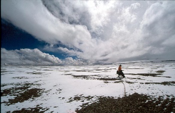
A great part of Chang Tang's 600.000 square
kilometres is covered by a wast high-altitude nature preserve covering an area
nearly 7 times the size of Denmark and ranks secondlargest on earth after ice-capped
northeast Greenland nature preserve. The enviroment is harsh in Chang Tang .
Snowstorms are common during the 4-season weather summer days at the arid windswept
4500 - 5000 meter northern plateau where saltine muddy sumps and lakes in-between
the waste numbers of mountains are common due to internal drainage. Annual
average temperature lays between 0 C and -6 C and the whole northern area is
basically one large-scale permafrost zone, hidden just beneath ground on the
alpine steppes. Wintertime is cruel, Bonvalot had a record of -44,5 C in January
1890. Sven Hedin measured average wind speed between 32-39 km/hr throughout
February 1908 and called it "30 days of storm". During one Chang Tang
crossing, Hedin and his caravan people didn't see human beings for 81 days.
 The
reserve contains a wide range of unique wildlife, among them are; Tibetan bears
(the Yeti is probably in reality this beast), wolfs, snowlepards, Tibetan antelopes,
wild asses, Tibetan Gazelle, Yaks, etc...
The
reserve contains a wide range of unique wildlife, among them are; Tibetan bears
(the Yeti is probably in reality this beast), wolfs, snowlepards, Tibetan antelopes,
wild asses, Tibetan Gazelle, Yaks, etc...
The remoteness of Chang Tang
is maybe best illustrated by the long ongoing debate on the location of the
Mekong river source. In winter 2002-03, at a time when most geographical mysteries
has been finally solved decades ago, it was announced that satellite photos
had revealed Mekong to be amazingly 700 km longer than former assumed, the source
presumably laying deep inside the eastern part of Chang Tang. The more I learn
about this ultimate remoteness, the more it scares me - especially after the
Keriya pass experience but somehow it punched its way into my heart.
This is what my last 7600 kilometres
Tibet bike trips have been about, preparing myself and test equipment before
a full solo crossing of Chang Tang. My 1.200 kilometres solo testtrip down from
Golmud to Lhasa during the coldest time of the year wasn't succesfull, finding
myself in company with people guarding the railroad constuction camps whenever
possible instead of camping alone in temperatures down to - 35 C. Last autumn's
4.600 km trip was tough in duration and hardship, especially the last 470 km
in desolated West Chang Tang. My equipment didn't withstand this test very succesfully;
one brokken rim, one brokken saddle, one brokken front rack, etc...
 BUT:
I can not keep testing myself and equipment forever. I'm going this autumn or
never. I have spend an enormous amount of time studing maps, finding high-resolution
satellite photos and finding litterature on the old explorers in the hope of
making the crossing easier and more safe. There is a risk of running into serious
unforseen problems, but I have gotten to the point where I accept it because
I really want to try it out, not only to become the first to make a unsupported
solocrossing and cross through places never seen by human beings before, but
primarly because I want to learn more about myself when being on the edge.
BUT:
I can not keep testing myself and equipment forever. I'm going this autumn or
never. I have spend an enormous amount of time studing maps, finding high-resolution
satellite photos and finding litterature on the old explorers in the hope of
making the crossing easier and more safe. There is a risk of running into serious
unforseen problems, but I have gotten to the point where I accept it because
I really want to try it out, not only to become the first to make a unsupported
solocrossing and cross through places never seen by human beings before, but
primarly because I want to learn more about myself when being on the edge.
Sadly, massive
amount of oil has likely been discovered in Chang Tang and now it only seems
like a matter of time before big bang oil industry will penetrate this ecological
fragile region in order to ensure energy to booming Chinese economy. If I hesitated
before, I am now more eager than ever before to experience this place in its
true spirit before economic progress cuts its way into the heart of ChangTang.
Expedition History in Chang Tang
hedin: one dead - Wellby: two dead
Two Germans, Steffan Simmerer
and Frank Kauper did the crossing together in June/July 1999, using modified
titanium horse sulkies for food and gear transportation. I fist came to hear
about them when a hotel manager in a Taklamakan desert town called Qiemo, suggested
I tried the road "two Danes with bicycle wagons" had used across central
Chang Tang. They ended up at his hotel after their trip. I had been trying to
get into west Tibet, but was stopped by severe flooding, and now this manager
told me two people had done a trip across central Tibet short time ago on road.
Two Danes! - and cycling on rickshaws as I understood it - too fantastic! I
ended up turned my tump down for an attempt. I felt lucky when I later learned
the real story about the Germans and Chang Tang. It took them 51 epic days to
walk the 1000 km route during which they didn't see human beings for 35 continuous
days. They even had the energy to make a ascent of Mt. Zangser Kangri in central
Chang Tang. Their astonishing achievement finally proved that crossing Chang
Tang not necessary needs to involve large animal caravans or sophisticated terrain
vehicles.
 Similarly,
but under much more dramatic circumstances did American Frank Bessac, Douglas
Mackiernan (CIA's first atomic spy) and three Russians cross south through Chang
Tang in 1950 when they fled the Communist army in the Xinjiang province. Three
of them were shot to death by Tibetan border guards near Silling Lake. Bessac
and a Russian survived the encounter and the two refugees eventually reached
Lhasa, finally accomplishing what Hedin, Littledale, Bowler, De Rhins among
other great explores attempted, but failed to do. Bottom line: The only real
challenge the two parties left behind in non-climbing terms is a solo crossing
of Chang Tang. This massive challenge has no room for mistakes
Similarly,
but under much more dramatic circumstances did American Frank Bessac, Douglas
Mackiernan (CIA's first atomic spy) and three Russians cross south through Chang
Tang in 1950 when they fled the Communist army in the Xinjiang province. Three
of them were shot to death by Tibetan border guards near Silling Lake. Bessac
and a Russian survived the encounter and the two refugees eventually reached
Lhasa, finally accomplishing what Hedin, Littledale, Bowler, De Rhins among
other great explores attempted, but failed to do. Bottom line: The only real
challenge the two parties left behind in non-climbing terms is a solo crossing
of Chang Tang. This massive challenge has no room for mistakes
The trip might end up with an
easy bicycle crossing of the Taklamakan desert on the paved desert highway.
_______________________________________________
Here a quote from Sven
Hedin's book "My life as an explorer", at a time when he nearly
one century ago was turned back by Tibetan border guards just before reaching
his ultimately goal in his explorations of Tibet - reaching Lhasa:
 "Listen...
do you really think I am so mad as to go back to the wastes in the north, where
I already lost half of my caravan? Wherever we may go, I shall never go there!"
"Listen...
do you really think I am so mad as to go back to the wastes in the north, where
I already lost half of my caravan? Wherever we may go, I shall never go there!"
On the other hand, George
Schaller:
"With its ecological wholeness,
stark beauty, and sense of unfettered freedom, it is a place where mind and
body can travel, where one's soul can dance. It is the essence of the Chang
Tang."
This place I need to experience
again.
/Martin